Good afternoon all,
Sad news continues to stream out of the Midwest as severe storms destroy homes and claim lives. My heart goes out to all of those affected, including those in Moore, OK. We’ll take some closer looks at severe storms and tornadoes as the spring and summer progress, but today I wanted to bring attention to a weather event you probably didn’t hear about.
On May 4th tropical-storm strength winds blew through the Chivela Pass in Mexico. This in itself may not seem too interesting but did you known there wasn’t any kind of tropical storm in the area? The winds were due to a Tehuantepecer, or Tehuano Wind, a local wind created by the region’s topography.

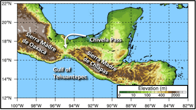
The Chivela Pass is a gap in the Sierra Madre Mountains on the isthmus of Tehuantepec in Mexico. Pressure differences between the air masses north (Gulf of Mexico) and south (Pacific Ocean) cause air to stream through the pass. The more significant the pressure difference, the stronger the winds. Because the air masses are so large and the pass is so small these winds can reach tropical storm or even hurricane force.

So what causes these pressure differences?
In the wintertime cold air masses with higher surface pressures move southward from the North American continent over the Gulf of Mexico. The Gulf of Tehuantepec to the south of the Chivela Pass does not see such influxes of cold air in the wintertime and will end up with a significantly lower pressure level. In an attempt to equalize the pressure, air starts to blow through the pass north to south. (Note: This pressure difference exists primarily as the lowest levels in the atmosphere so air cannot simply flow over the tall Sierra Madres.)
But it was May?
True! And that is what made this particular event so rare. This Tehuantepecer was caused by a mid-latitude cyclone (a.k.a. synoptic storm, large storm system) that was moving across the country. This very same cyclone had caused breakouts of severe weather in the days previous. (Additional note: The word “cyclone” here refers to something on a completely different scale then a tornado or even hurricane, cyclones of this size are associated with your typical cold front.)

While the Tehuano wind is destructive, it also serves an important role to the local ecosystem. The strong winds churns the water in the Gulf of Tehuantepec and stimulates algal blooms, fueling an entire food chain! To learn more check out this article by NASA’s Earth Observatory.
Don’t worry, a run-down of the predictions for this years’s hurricane season is still coming. The season begins June 1st.
~Wildcard
