
Welcome back everyone,
It seems lake-effect snow has become this year’s polar vortex, so there’s no more timely subject to write about this week. This week’s Buffalo snow,lasting from Monday, November 17th to Thursday, November 20th was truly a historic and devastating event. Over seven feet of snow has fallen on some areas and at least 12 deaths has been blamed on the storm. The pictures and video have been incredible…
How does this happen? What is lake-effect snow? Why is Buffalo hit so hard this week? Let’s take a look.
Lake-Effect Snow
The Great Lakes along the US-Canada border are some of the largest in the world. They’re also in an area where air temperatures drop well below freezing much of the year. November, although not meteorological winter, is one of those months. And while air temperatures can drop below freezing, the temperature of the lake water is much warmer. As of this post, on November 22nd, Lake Erie is 40 degrees F and Lake Ontario is 45 F.
Current lake temperatures are available here and provided by NWS-Buffalo.
When freezing-cold air moves over warmer water, the air right at the water surface warms. The warm air then does what warm air always does when it is below colder air: it rises. The rising of warm air is known as convection and the rate of convection dictates if precipitation will occur and how severe it will be. In fact, if enough convection occurs you can get thunder and lightning inside a snow storm. Once the rising, moist air gets to a cold-enough air level, the water vapor condenses and then freezes into snow clouds. These snow clouds almost immediately begin to release their payload and travel it whatever direction the wind is blowing. When they reach land, the speed of the clouds is decreased by friction. The clouds bunch up and release all of their snow over a relatively thin area right along the lake’s coast.

Fetch
The direction in which the wind is blowing is very important. This is due to fetch. Fetch is the surface length of lake upstream of the coastal area receiving snow. The longer the fetch, the more moisture can rise and form snow. Since the prevailing wind direction is from the west, Lakes Erie and Ontario have long fetches while Lakes Michigan and Huron have short fetches. Buffalo, at the eastern edge of Lake Erie, receives so much lake-effect snow because it has a long fetch.

The November 17th-20th Storm
Here is the surface chart from Monday the 17th and Tuesday 18th…
You see a couple things in these surface charts. The first is a cold front the moves over Lake Erie and Buffalo, NY. This brings in the frigid air temperatures that create the strong convection over the lake surface. There is also an area of low pressure over eastern Canada with air moving counter-clockwise around it. This creates the long fetch necessary for high snow totals. This low danced around the Ontario area through Thursday, the 20th and kept winds coming from the right direction to produce more snow.
It is this set-up, along with the warmer lake temperatures, that created this incredible snowfall. Syracuse.com has an interactive snow total map. Some highlights are 79 inches in Orchard Park (where the Buffalo Bills play) and 90.5 inches in East Aurora.
When does it stop?
Thankfully, this kind of weather does not persist throughout the entire winter. Eventually, the lake will freeze over or at least get too cold for any significant convection. The timing of this varies from year to year but on average occurs sometime in January. Here’s Buffalo’s snow totals by month…
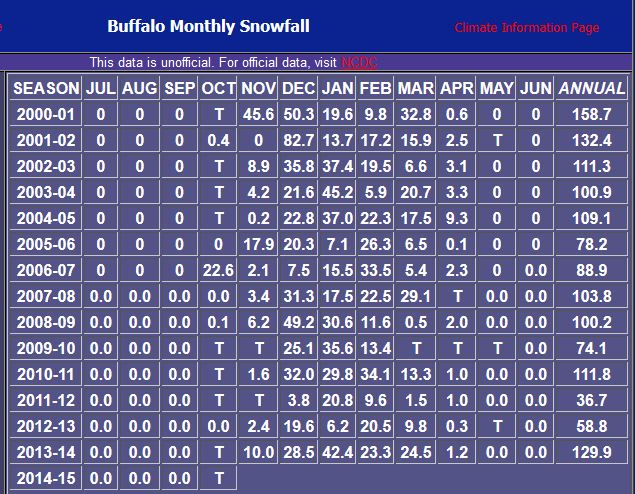 There big, big totals are in November, December, and January. See 45.6 inches in November 2000, 82.7 inches in December 2001, and 49.6 inches in December 2008. Snow totals by no means dwindle after the lake freezes, but the removal of a source of snowfall does drop the monthly totals.
I hope this was a solid introduction to the science of lake-effect snow.Even more important than the science however, is the people who have been affected. The snow has trapped thousands in their homes and claimed several lives. To all of those in the Buffalo area, the thoughts of the meteorological community are with you.
As always, you can e-mail me with any questions at wildcardweather@gmail.com or tweet me @wildcardweather. Thank you for reading!
~Wildcard

1 Comment