
Good afternoon everyone,
Before I begin talking about one of my favorite subjects in all of meteorology, let’s check on Andrea.
Andrea is still a tropical storm (somehow, it’s gone over a lot of land). It’s over North Carolina and is moving northeast. It’s created a few tornadoes and some flash flooding, but overall it’s effects have not been serious. It has moved quickly since being spawned in the Gulf of Mexico and will be over the Canadian maritimes by Sunday morning.
What’s steering it?
The storm is being steered by two large-scale atmospheric features; a dip in the subtropical jet and high pressure off the southeastern coastline.
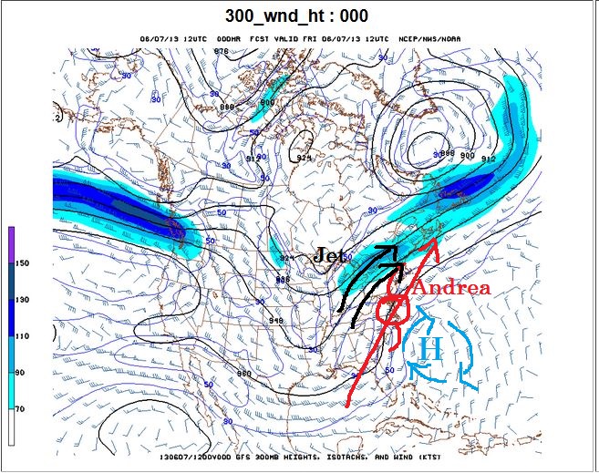
This is a 300 mb wind chart (along with my fantastic drawing. 300 mb is almost at the top of the troposphere, the lowest level of the atmosphere where weather occurs. This is where the jet stream sets up. In this map, the blue shaded regions are where the jet is strongest. Looking at the map you can see the jet come on shore just north of Washington state and then dipping down into Louisiana. It then turns north-northeast and goes into eastern Canada.
Also labeled on this chart is an area of upper-level (referring to its place in the troposphere) high pressure. Air moves clockwise around high pressure, and that is reflected in the wind barbs. Andrea formed near the bottom of this dip in the jet stream, also known as a trough. It is now moving along with the jet stream, which itself is moving around the high pressure. This is why it is moving north-northeast and also why it is moving so quickly. According to the National Hurricane Center it is moving 24 knots, or 28 mph.

That’s all for now. I’m already working on my next post on cloud seeding. I hope to get it up soon. Stay dry!
~Wildcard
